Water’s Wrath: Historic flooding trends highlight need for flash flood safety
ST. JOSEPH, Mo. (KQTV) -- Flooding along the Missouri River has shaped communities across Northwest Missouri and Northeast Kansas for decades, with historic events like the Great Flood of 1993 and the 2019 Midwest floods serving as reminders of the region’s vulnerability.
The Missouri River has a long history of rising beyond its banks, flooding homes, farmland and infrastructure. While some years bring minor impacts, others have caused widespread devastation.
The 1993 flood remains one of the most catastrophic natural disasters in U.S. history. Persistent rainfall over the central United States throughout the spring and summer led to record-breaking river levels across the Midwest. The Missouri and Mississippi rivers and their tributaries remained above flood stage for months, inundating millions of acres of land.
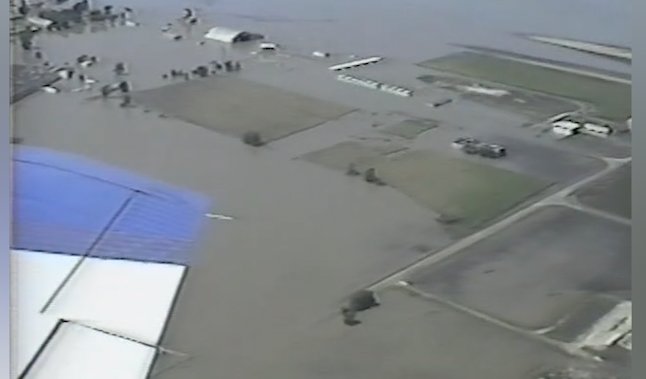
Entire communities were cut off, thousands of homes were destroyed and damages reached into the billions of dollars. The flood also reshaped floodplain management and river forecasting for decades to follow.
More recently, the region experienced significant flooding again in 2019. That event was driven by a combination of heavy snowfall during the winter and a rapid warm-up in early spring, which caused widespread snowmelt. Frozen ground conditions prevented water from soaking into the soil, forcing runoff into rivers and streams.
"There was even more water in the snow, anywhere from four to seven inches, so there was a lot of water just sitting there waiting to be released,” said Scott Watson, a lead hydrologist with the National Weather Service.
The sudden release of water, combined with rainfall, led to rapid rises along the Missouri River, causing levee breaches and widespread flooding across parts of Missouri, Iowa, Nebraska and Kansas.
While river flooding often develops over several days, flash flooding can occur more quickly and with little warning. Flash flooding is typically caused by intense rainfall over a short period of time and can become life-threatening within minutes.
Even areas experiencing dry conditions are not immune.
"Some parts of our area are still in drought, but you can still have flash flooding in those situations if you get enough rainfall,” Watson said.
Flooding remains one of the deadliest weather hazards in the United States, particularly when it comes to drivers. According to data from the Centers for Disease Control and Prevention and the National Weather Service, more than half of flood-related deaths involve vehicles.
"Pretty simple — don’t drive into floodwaters,” Watson said. “We see water rescues every year. Sometimes it’s at night, it’s hard to see, and you’re in the water before you know it. That water moves fast, and you may not even know where the road is.”
Floodwaters can also conceal serious hazards beneath the surface.
"It can wash the road out, and you don’t know it — it could be gone underneath the water,” Watson added.
Just six inches of moving water can knock a person off their feet, while 12 inches can carry away a car. At 18 inches, even larger vehicles like trucks can be swept away.
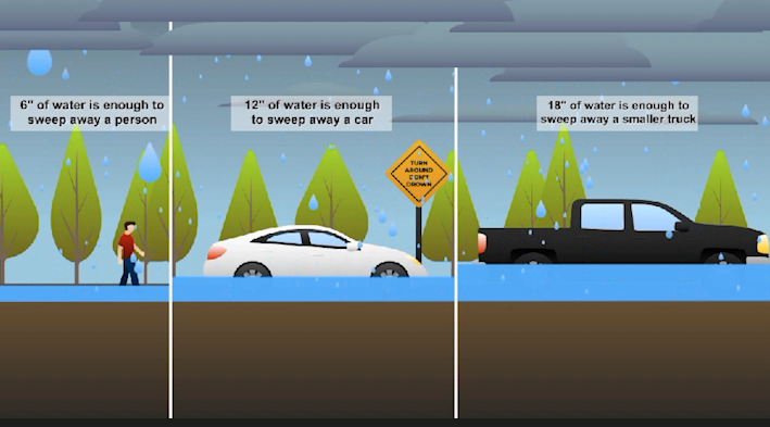
Emergency officials urge drivers to follow the phrase “Turn Around, Don’t Drown” and never attempt to cross flooded roadways.
Understanding flood alerts is also critical. A flood watch indicates that conditions are favorable for flooding to develop, while a flood warning means flooding is already occurring or imminent.
Warnings can remain in effect even after rainfall ends, as long as floodwaters continue to pose a threat.
As the region moves deeper into spring and severe weather season, recent rainfall and saturated ground conditions can increase the risk of flooding. Even areas that do not typically flood can quickly become dangerous during periods of heavy rain.
Officials say staying weather-aware, having a plan and taking warnings seriously can make all the difference when floodwaters begin to rise.
Tune into KQ2 News at 6 p.m. to watch this Special Report.
